Geolocate

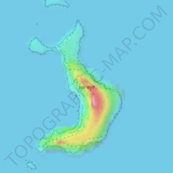
Wolf topographic map

Click on the map to display elevation.

Wolf

Wolf Island (Spanish: Isla Wolf) is a small island in the northern Galápagos Islands. It has an area of 1.3 km2 (0.5 sq mi) and a maximum altitude of 253 m (830 ft) above sea level. The island is remote from the main archipelago and has no permanent population. The Galápagos National Park does not allow landing on the island; however, it is a popular diving location.

Wikipedia (CC-BY-SA 3.0)

About this map

Name: Wolf topographic map, elevation, terrain.

Location: Wolf, Parroquia Tomás de Berlanga (Santo Tomás), Cantón Isabela, Galápagos, Ecuador (1.37405 -91.82592 1.39499 -91.81133)

Average elevation: 15 m

Minimum elevation: 0 m

Maximum elevation: 248 m

Other topographic maps

Click on a map to view its topography, its elevation and its terrain.
Isla Fernandina

Ecuador > Galápagos > Cantón Isabela

Average elevation: 201 m

Isla Fernandina

Ecuador > Galápagos > Cantón Isabela

Average elevation: 201 m

Isla Tortuga

Ecuador > Galápagos > Cantón Isabela

Average elevation: 4 m

Gear up for your next adventure:

🎒Multi-day Trekking Packs - Large capacity backpacks for wild camping and long-distance trails
🥾Women's Waterproof Hiking Boots - High-performance trekking boots designed for all-weather comfort
GPS Outdoor Watches - Watches with GPS tracking for hiking and exploration
🗺️Ordnance Survey Maps - Essential paper maps for hiking across the UK national parks
🧵Survival Paracord - Multi-purpose cordage for emergency repairs and shelters

As an Amazon Associate, this site earns from qualifying purchases at no extra cost to you.