Geolocate

Sari topographic map

Click on the map to display elevation.

About this map

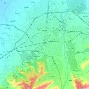
Name: Sari topographic map, elevation, terrain.

Location: Sari, بخش مرکزی, Sari County, Mazandaran Province, Iran (36.50045 53.00755 36.60171 53.13700)

Average elevation: 55 m

Minimum elevation: -3 m

Maximum elevation: 302 m

Other topographic maps

Click on a map to view its topography, its elevation and its terrain.

Farim

Iran > Mazandaran Province > Sari County > Farim

Average elevation: 894 m

خلرد

Iran > Mazandaran Province > Sari County > Chahardangeh

Average elevation: 1,440 m

Gear up for your next adventure:

📦Dry Bags - Waterproof bags to protect gear from rain
👟Waterproof Leg Gaiters - Keep mud and water out of your boots in boggy terrain
🧺Mesh Stuff Sacks - Breathable storage for wet gear or camp organization
🐕Hiking Dog Harnesses - Rugged harnesses for taking your companion on mountain trails
🥾Men's Waterproof Hiking Boots - Durable footwear with deep lugs for muddy and rocky UK terrains

As an Amazon Associate, this site earns from qualifying purchases at no extra cost to you.