Geolocate

Labo topographic map

Click on the map to display elevation.

About this map

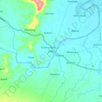
Name: Labo topographic map, elevation, terrain.

Location: Labo, Camarines Norte, Bicol Region, Philippines (14.11435 122.78852 14.19435 122.86852)

Average elevation: 30 m

Minimum elevation: -1 m

Maximum elevation: 207 m

Other topographic maps

Click on a map to view its topography, its elevation and its terrain.

Bagasbas Beach

Philippines > Camarines Norte > Daet > Bagasbas

Average elevation: 1 m

Daet

Philippines > Camarines Norte

Average elevation: 6 m

Vinzons

Philippines > Camarines Norte

Average elevation: 10 m

Tailon Island

Philippines > Camarines Norte

Average elevation: 0 m

Gear up for your next adventure:

🧵Survival Paracord - Multi-purpose cordage for emergency repairs and shelters
🧺Microfibre Travel Towels - Fast-drying and compact towels for wild swimming and camping
📷Camera Straps - Secure straps for carrying cameras while walking
👖Convertible Hiking Trousers - Versatile zip-off pants for changing mountain weather conditions
🗺️Ordnance Survey Maps - Official UK maps for walking and outdoor activities

As an Amazon Associate, this site earns from qualifying purchases at no extra cost to you.