
Make a donation
Gear up for your next adventure:
As an Amazon Associate, this site earns from qualifying purchases at no extra cost to you.
La Merced topographic map
Click on the map to display elevation.
Make a donation
Gear up for your next adventure:
As an Amazon Associate, this site earns from qualifying purchases at no extra cost to you.
La Merced
La ciudad en un importante centro comercial agrícola de la selva central. Está a una altitud de 750 m.s.n.m. sobre la orilla occidental del río Chanchamayo, que luego se convierte en el río Perené. Las áreas circundantes de la ciudad cuentan con cascadas, ríos y bosque de selva con abundante vida silvestre.
Make a donation
Gear up for your next adventure:
As an Amazon Associate, this site earns from qualifying purchases at no extra cost to you.
About this map
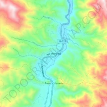
Name: La Merced topographic map, elevation, terrain.
Location: La Merced, Chanchamayo, Junín, Perú (-11.09560 -75.36834 -11.01560 -75.28834)
Average elevation: 1,079 m
Minimum elevation: 707 m
Maximum elevation: 1,748 m
Make a donation
Gear up for your next adventure:
As an Amazon Associate, this site earns from qualifying purchases at no extra cost to you.
Other topographic maps
Click on a map to view its topography, its elevation and its terrain.