
Kleefeld topographic map
Interactive map
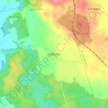
Click on the map to display elevation.
About this map
Name: Kleefeld topographic map, elevation, terrain.
Average elevation: 78 m
Minimum elevation: 42 m
Maximum elevation: 124 m
Other topographic maps
Click on a map to view its topography, its elevation and its terrain.
Hogendorf
Polen > Woiwodschaft Ermland-Masuren > powiat braniewski
Hogendorf, Gemeinde Plaßwich, powiat braniewski, Woiwodschaft Ermland-Masuren, 14-526, Polen
Average elevation: 115 m
Rödersdorf
Polen > Woiwodschaft Ermland-Masuren > powiat braniewski
Rödersdorf, Gemeinde Braunsberg, powiat braniewski, Woiwodschaft Ermland-Masuren, 14-500, Polen
Average elevation: 108 m
Klenau
Polen > Woiwodschaft Ermland-Masuren > powiat braniewski
Klenau, gmina Braniewo, powiat braniewski, Woiwodschaft Ermland-Masuren, 14-500, Polen
Average elevation: 0 m
Auhof
Polen > Woiwodschaft Ermland-Masuren > powiat braniewski
Auhof, gmina Braniewo, powiat braniewski, Woiwodschaft Ermland-Masuren, 14-500, Polen
Average elevation: 1 m