
Condado de Cork topographic map
Interactive map
Click on the map to display elevation.
About this map
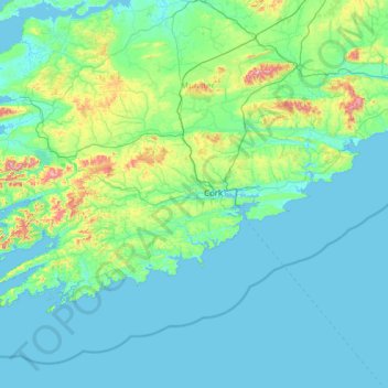
Name: Condado de Cork topographic map, elevation, terrain.
Location: Condado de Cork, Munster, Irlanda (51.38887 -10.30252 52.38779 -7.84107)
Average elevation: 78 m
Minimum elevation: -2 m
Maximum elevation: 990 m
Other topographic maps
Click on a map to view its topography, its elevation and its terrain.
New Ross Municipal District
New Ross Municipal District, The Municipal District of New Ross, Condado de Wexford, Leinster, Irlanda
Average elevation: 63 m
Middleton ED
Middleton ED, The Municipal District of Athlone — Moate, County Westmeath, Condado de Westmeath, Leinster, N91 W97W, Irlanda
Average elevation: 89 m
Waterford
Irlanda > Condado de Waterford
Waterford, Condado de Waterford, Munster, Irlanda
Average elevation: 33 m
Copperalley ED
Copperalley ED, The Municipal District of Mullingar — Kinnegad, County Westmeath, Condado de Westmeath, Leinster, Irlanda
Average elevation: 78 m
Collum
Collum, Cashel West ED, Ballymahon Municipal District, County Longford, Condado de Longford, Leinster, Irlanda
Average elevation: 38 m
Blackrock
Blackrock, Dún Laoghaire-Rathdown, County Dublin, Leinster, A94 VP03, Irlanda
Average elevation: 30 m
Camea
Irlanda > Condado de Tipperary
Camea, Kilfeakle, The Municipal District of Cahir — Cashel, Condado de Tipperary, Munster, Irlanda
Average elevation: 103 m
Morning Star
Morning Star, Condado de Limerick, Munster, V35 YW50, Irlanda
Average elevation: 98 m
Castlebar
Irlanda > County Mayo > Castlebar
Castlebar, Castlebar Municipal District, County Mayo, Connacht, F23 DP02, Irlanda
Average elevation: 56 m
Galway
Irlanda > County Galway > Galway
Galway, County Galway, Connacht, Irlanda
Average elevation: 16 m
Derryoober West
Derryoober West, Coos ED, Loughrea Municipal District, County Galway, Connacht, Irlanda
Average elevation: 100 m
Mullingar
Irlanda > County Westmeath > Mullingar
Mullingar, The Municipal District of Mullingar — Kinnegad, County Westmeath, Leinster, N91 FY58, Irlanda
Average elevation: 101 m
The Borough District of Drogheda
The Borough District of Drogheda, County Louth, Leinster, Irlanda
Average elevation: 50 m
Plaster
Plaster, Ballymascanlan ED, The Municipal District of Dundalk, County Louth, Leinster, Irlanda
Average elevation: 55 m
Drom Mullac House
Drom Mullac House, L5503, Killashandra ED, Cavan-Belturbet Municipal District, County Cavan, H14 YY97, Irlanda
Average elevation: 68 m
The Warren Dunes
The Warren Dunes, Pier Road, English Island, Rosscarbery, West Cork, County Cork, Munster, Irlanda
Average elevation: 23 m
The Metropolitan District of Limerick City
Irlanda > The Metropolitan District of Limerick City
The Metropolitan District of Limerick City, County Limerick, Munster, Irlanda
Average elevation: 44 m
St. Patricksrock
St. Patricksrock, Cashel Rural, The Municipal District of Cahir — Cashel, County Tipperary, Munster, Irlanda
Average elevation: 101 m
Maryborough
Maryborough, Portlaoise Rural ED, The Municipal District of Portlaoise, County Laois, Leinster, R32 KV20, Irlanda
Average elevation: 96 m
Crean
Irlanda > The Municipal District of Cappamore — Kilmallock
Crean, The Municipal District of Cappamore — Kilmallock, County Limerick, Munster, Irlanda
Average elevation: 56 m
Cloghbrack
Cloghbrack, The Municipal District of Trim, County Meath, Leinster, Irlanda
Average elevation: 70 m
North Bull Island
North Bull Island, Raheny St. Assam ED, Dublin 5, Dublin, County Dublin, Leinster, Irlanda
Average elevation: 2 m
Aghaviller
Aghaviller, The Municipal District of Callan — Thomastown, County Kilkenny, Leinster, Irlanda
Average elevation: 142 m
Slievemahanagh ED
Slievemahanagh ED, Westport-Belmullet Municipal District, County Mayo, Connacht, Irlanda
Average elevation: 122 m
Rathrobin ED
Rathrobin ED, The Municipal District of Tullamore, County Offaly, Leinster, Irlanda
Average elevation: 90 m
Rathfeston ED
Rathfeston ED, The Municipal District of Edenderry, County Offaly, Leinster, Irlanda
Average elevation: 83 m