
Make a donation
Gear up for your next adventure:
As an Amazon Associate, this site earns from qualifying purchases at no extra cost to you.
Wansfell Pike topographic map
Click on the map to display elevation.
Make a donation
Gear up for your next adventure:
As an Amazon Associate, this site earns from qualifying purchases at no extra cost to you.
Wansfell Pike
Wansfell has an extensive summit ridge with two tops. The highest point of the fell is called Baystones with a height of 488 m (1,601 ft), while Wansfell Pike, which lies a kilometre to the south west reaches an elevation of 482 m (1,581 ft). Of the two summits, Wansfell Pike is regarded as the “true” summit of the fell by many fell walkers because of its superior view, even though it is the lower of the pair.
Make a donation
Gear up for your next adventure:
As an Amazon Associate, this site earns from qualifying purchases at no extra cost to you.
About this map
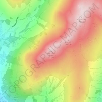
Name: Wansfell Pike topographic map, elevation, terrain.
Average elevation: 285 m
Minimum elevation: 53 m
Maximum elevation: 484 m
Westmorland and Furness trails, hiking, mountain biking, running and outdoor activities
Make a donation
Gear up for your next adventure:
As an Amazon Associate, this site earns from qualifying purchases at no extra cost to you.
Other topographic maps
Click on a map to view its topography, its elevation and its terrain.