Geolocate

Labankar topographic map

Click on the map to display elevation.

About this map

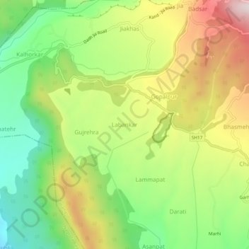
Name: Labankar topographic map, elevation, terrain.

Location: Labankar, Palampur, Kangra, Himachal Pradesh, 176059, India (32.11910 76.42693 32.15910 76.46693)

Average elevation: 1,224 m

Minimum elevation: 972 m

Maximum elevation: 1,548 m

Other topographic maps

Click on a map to view its topography, its elevation and its terrain.

Neugal Rivulet

India > Himachal Pradesh > Palampur

Average elevation: 1,019 m

Banuri

India > Himachal Pradesh > Palampur

Average elevation: 1,254 m

Dhauladhar

India > Himachal Pradesh > Palampur

Average elevation: 2,577 m

Kandbari

India > Himachal Pradesh > Palampur

Average elevation: 1,424 m

Nanahar

India > Himachal Pradesh > Palampur

Average elevation: 1,610 m

Gear up for your next adventure:

🕶️Polarized Sunglasses - Reduces glare from snow and water when reading terrain
🧣Neck Gaiters - Versatile protection against wind and cold
📦Compression Sacks - Reduce backpack volume efficiently
🥾Walking Shoes - Lightweight walking shoes for countryside and coastal paths
🐕Dog Hiking Gear - Equipment for hiking safely with dogs

As an Amazon Associate, this site earns from qualifying purchases at no extra cost to you.