
Make a donation
Gear up for your next adventure:
As an Amazon Associate, this site earns from qualifying purchases at no extra cost to you.
Castillo de Serra topographic map
Click on the map to display elevation.
Make a donation
Gear up for your next adventure:
As an Amazon Associate, this site earns from qualifying purchases at no extra cost to you.
About this map
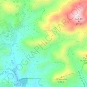
Name: Castillo de Serra topographic map, elevation, terrain.
Average elevation: 415 m
Minimum elevation: 256 m
Maximum elevation: 714 m
Make a donation
Gear up for your next adventure:
As an Amazon Associate, this site earns from qualifying purchases at no extra cost to you.
Other topographic maps
Click on a map to view its topography, its elevation and its terrain.
Parque Natural de la Sierra Calderona
España > Comunidad Valenciana > Serra
Esta sierra ocupa una vasta superficie que se desarrolla principalmente por debajo de los 1000 metros de altitud, con excepción del Montemayor, en el extremo noroccidental, donde se alcanza una cota de 1.015 metros sobre el nivel del mar. Otras alturas importantes son el Gorgo (907 metros), Pico del Águila…
Average elevation: 401 m