
Make a donation
Gear up for your next adventure:
As an Amazon Associate, this site earns from qualifying purchases at no extra cost to you.
As Donas topographic map
Click on the map to display elevation.
Make a donation
Gear up for your next adventure:
As an Amazon Associate, this site earns from qualifying purchases at no extra cost to you.
About this map
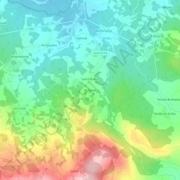
Name: As Donas topographic map, elevation, terrain.
Location: As Donas, Vilalvite, Friol, Lugo, Galicia, España (42.99955 -7.73538 43.03955 -7.69538)
Average elevation: 525 m
Minimum elevation: 445 m
Maximum elevation: 688 m
Make a donation
Gear up for your next adventure:
As an Amazon Associate, this site earns from qualifying purchases at no extra cost to you.
Other topographic maps
Click on a map to view its topography, its elevation and its terrain.
Serra do Careón
España > Galicia > Lugo > Friol
Con una altitud media de 550 metros y máxima de 798 metros, en el monte Careón. Dominan los granitos intrusivos, gneis de "ojo de sapo" y esquistos. En esta sierra nacen el río Narla, afluente del Miño, y el río Pambre, el río Seco y el río Furelos, afluentes los tres del río Ulla.
Average elevation: 730 m