
Flores da Cunha topographic map
Interactive map
Click on the map to display elevation.
Flores da Cunha
Because of the Altitude of 756 meters above the sea level, The Climate of Flores da Cunha is Oceanic Climate type Cfb. With warm (not hot) to cool summers with some few experiences of snowfall between July and August.
About this map
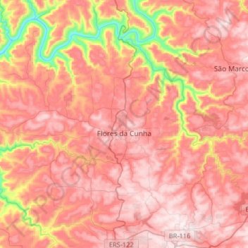
Name: Flores da Cunha topographic map, elevation, terrain.
Average elevation: 660 m
Minimum elevation: 230 m
Maximum elevation: 891 m
Other topographic maps
Click on a map to view its topography, its elevation and its terrain.
Porto Alegre
Brazil > Rio Grande do Sul > Metropolitan Region of Porto Alegre > Porto Alegre
Porto Alegre has a long coastline on the Guaíba Lake, and its topography is punctuated by 40 hills. In the lake, a vast body of water, a maze of islands facing the city creates an archipelago where a unique ecosystem gives shelter to abundant wildlife. The city area concentrates 28% of the native flora of Rio…
Average elevation: 27 m
Pelotas
Brazil > Rio Grande do Sul > Aglomeração Urbana do Sul > Pelotas
As it is situated on a plain near the ocean, the urban area lies on a low elevation, being, on average, 7 meters (23 ft) above sea level. The interior of the municipality is on a plateau called Serras de Sudeste (Southeastern Mountain Ranges). Consequently, the altitude in Pelotas' rural area reaches 429…
Average elevation: 18 m
Parobé
Brazil > Rio Grande do Sul > Metropolitan Region of Porto Alegre > Parobé > Parobé
Average elevation: 62 m