
Make a donation
Gear up for your next adventure:
As an Amazon Associate, this site earns from qualifying purchases at no extra cost to you.
Bradgate Park topographic map
Click on the map to display elevation.
Make a donation
Gear up for your next adventure:
As an Amazon Associate, this site earns from qualifying purchases at no extra cost to you.
Bradgate Park
Overlying the Beacon Hill Formation, but found a little further down the hillside to the south, are the Bradgate Formation beds, the most notable of which is the Sliding Stone Slump Breccia rocks. Forming a line of crags below Old John, these are laminated mudstones, with layers of sandstone, mainly of volcanic origin. The beds are substantially warped, contorted and folded. Many of the more intricate folds and 'sag' patterns are thought to have occurred while the sediments were unconsolidated and water saturated. Suggested causes for these include slumping, earth tremors and fault-movements, trapped water or gases and volcanic bomb impacts. Outcrops of other rocks of the Bradgate Formation are found further down the slope. These are younger than and stratigraphically above the breccia, but the uplift from ancient mountain-building, the dip of the beds and erosion of overlying rocks mean that the younger rocks are encountered at progressively lower altitudes.
Make a donation
Gear up for your next adventure:
As an Amazon Associate, this site earns from qualifying purchases at no extra cost to you.
About this map
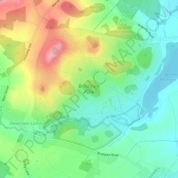
Name: Bradgate Park topographic map, elevation, terrain.
Average elevation: 126 m
Minimum elevation: 77 m
Maximum elevation: 209 m
Leicestershire trails, hiking, mountain biking, running and outdoor activities
Make a donation
Gear up for your next adventure:
As an Amazon Associate, this site earns from qualifying purchases at no extra cost to you.
Other topographic maps
Click on a map to view its topography, its elevation and its terrain.
Old John
United Kingdom > England > Leicestershire > Charnwood > Newtown Linford
Average elevation: 143 m