Elvas topographic map
Click on the map to display elevation.
Elvas
Elvas has a hot summer mediterranean climate (Köppen climate classification: Csa) with mild winters, although occasionally temperatures may drop below 0 °C (32 °F) and very hot, dry summers, where temperatures occasionally exceed 40 °C (104 °F). Elvas climate is quite similar to that of Badajoz, being slightly cooler and more humid due to its higher altitude and greater influence from the Atlantic Ocean. Precipitation varies from 500 to 600 mm (20 to 24 in) throughout the year, with an average of about 534 mm (21.0 in) annually. It is one of the hottest cities in Portugal during the summer, with an average maximum temperature close to 35 °C (95 °F).
About this map
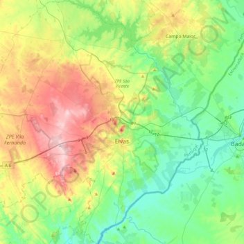
Name: Elvas topographic map, elevation, terrain.
Location: Elvas, Portalegre, Portugal (38.75150 -7.42429 39.05719 -7.03286)
Average elevation: 258 m
Minimum elevation: 143 m
Maximum elevation: 492 m
Other topographic maps
Click on a map to view its topography, its elevation and its terrain.

Relva da Asseiceira
Portugal > Portalegre > Marvão > Santo António das Areias
Average elevation: 482 m