
Chesterbrook topographic map
Click on the map to display elevation.
About this map
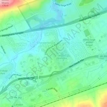
Name: Chesterbrook topographic map, elevation, terrain.
Average elevation: 70 m
Minimum elevation: 32 m
Maximum elevation: 190 m
Other topographic maps
Click on a map to view its topography, its elevation and its terrain.
Strafford
United States > Pennsylvania > Chester County > Tredyffrin Township
Average elevation: 133 m
Baptist Hill
United States > Pennsylvania > Chester County > Tredyffrin Township
Average elevation: 102 m
Paoli
United States > Pennsylvania > Chester County > Tredyffrin Township > Paoli
Average elevation: 128 m