
Hardegsen topographic map
Interactive map
Click on the map to display elevation.
About this map
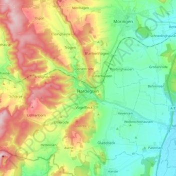
Name: Hardegsen topographic map, elevation, terrain.
Location: Hardegsen, Landkreis Northeim, Niedersachsen, 37181, Deutschland (51.59739 9.73164 51.71210 9.88756)
Average elevation: 239 m
Minimum elevation: 127 m
Maximum elevation: 436 m
Hardegsen liegt westlich der Leine und östlich des Sollings, direkt am südwestlichen Rand des Höhenzuges Weper. Hardegsen wird von der Espolde durchflossen, in die im Stadtgebiet der Schöttelbach mündet.