
Stieldorf topographic map
Interactive map
Click on the map to display elevation.
About this map
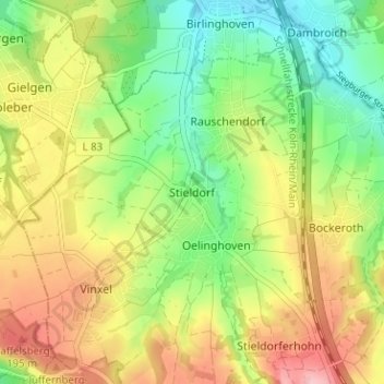
Name: Stieldorf topographic map, elevation, terrain.
Average elevation: 143 m
Minimum elevation: 77 m
Maximum elevation: 224 m
Zum Stadtteil Stieldorf gehören die Ortsteile Bockeroth, Düferoth, Frankenforst, Freckwinkel, Friedrichshöhe, Heiderhof, Höhnerhof, Niederscheuren, Oberscheuren, Oelinghoven, Rauschendorf, Sonderbusch, Sonnenbergerhof, Stieldorf, Stieldorferhohn und Vinxel.