Geolocate

The Municipal District of Kilkenny City topographic map

Interactive map

Click on the map to display elevation.

About this map

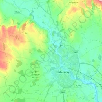
Name: The Municipal District of Kilkenny City topographic map, elevation, terrain.

Location: The Municipal District of Kilkenny City, County Kilkenny, Leinster, Ireland (52.62228 -7.35317 52.71983 -7.18861)

Average elevation: 84 m

Minimum elevation: 35 m

Maximum elevation: 220 m

Other topographic maps

Click on a map to view its topography, its elevation and its terrain.

The Rower

Ireland > County Kilkenny

Average elevation: 95 m

Coon

Ireland > County Kilkenny

Average elevation: 221 m

Priory

Ireland > County Kilkenny

Average elevation: 63 m

Kilmacow

Ireland > County Kilkenny > Kilmacow

Average elevation: 28 m

Mooncoin

Ireland > County Kilkenny > Mooncoin

Average elevation: 31 m