Geolocate

Whitetop topographic map

Click on the map to display elevation.

About this map

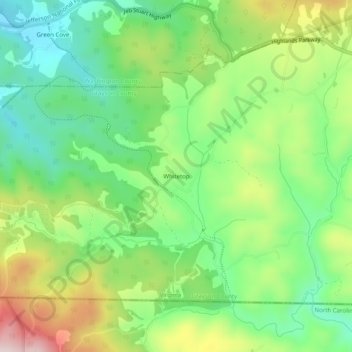
Name: Whitetop topographic map, elevation, terrain.

Location: Whitetop, Grayson County, Virginia, 24292, United States (36.58151 -81.64567 36.62151 -81.60567)

Average elevation: 1,107 m

Minimum elevation: 953 m

Maximum elevation: 1,364 m

Other topographic maps

Click on a map to view its topography, its elevation and its terrain.

Independence

United States > Virginia > Grayson County

Average elevation: 817 m

Troutdale

United States > Virginia > Grayson County

Average elevation: 999 m

Fries

United States > Virginia > Grayson County

Average elevation: 710 m

Troutdale

United States > Virginia > Grayson County

Average elevation: 999 m

Independence

United States > Virginia > Grayson County

Average elevation: 817 m

Fries

United States > Virginia > Grayson County

Average elevation: 710 m

Gear up for your next adventure:

🧗Locking Carabiners - Secure gear to your pack or for light technical use
🧺Ultralight Dry Bags - Organize and waterproof your gear inside your rucksack
📦Dry Bags - Waterproof bags to protect gear from rain
🎒Hiking Backpacks - Comfortable backpacks for day hikes and multi-day treks
🥾Hiking Boot Waterproofing Wax - Maintain the lifespan of your leather trekking boots

As an Amazon Associate, this site earns from qualifying purchases at no extra cost to you.