Geolocate

Fries topographic map

Click on the map to display elevation.

About this map

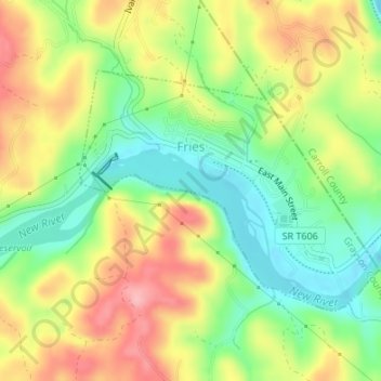
Name: Fries topographic map, elevation, terrain.

Location: Fries, Grayson County, Virginia, United States (36.70461 -80.98844 36.72282 -80.96201)

Average elevation: 710 m

Minimum elevation: 647 m

Maximum elevation: 784 m

Other topographic maps

Click on a map to view its topography, its elevation and its terrain.

Whitetop

United States > Virginia > Grayson County

Average elevation: 1,107 m

Elk Creek

United States > Virginia > Grayson County

Average elevation: 809 m

Elk Creek

United States > Virginia > Grayson County

Average elevation: 809 m

Whitetop

United States > Virginia > Grayson County

Average elevation: 1,107 m

Carsonville

United States > Virginia > Grayson County

Average elevation: 786 m

Rugby

United States > Virginia > Grayson County

Average elevation: 986 m

Gear up for your next adventure:

👟Men's Trail Running Shoes - Lightweight grip for fast movement over topographic contours
🎿Telescopic Trekking Poles - Reduces knee strain on steep topographic descents
🗺️Ordnance Survey Maps - Official UK maps for walking and outdoor activities
🌦️Portable Weather Meters - Handheld tools for monitoring weather conditions
GPS Outdoor Watches - Watches with GPS tracking for hiking and exploration

As an Amazon Associate, this site earns from qualifying purchases at no extra cost to you.