
Make a donation
Gear up for your next adventure:
As an Amazon Associate, this site earns from qualifying purchases at no extra cost to you.
Northville topographic map
Click on the map to display elevation.
Make a donation
Gear up for your next adventure:
As an Amazon Associate, this site earns from qualifying purchases at no extra cost to you.
About this map
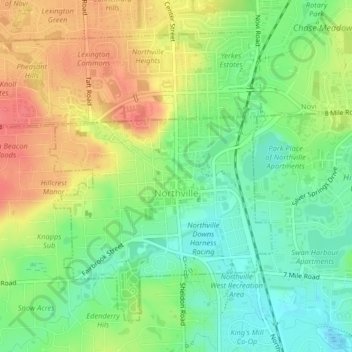
Name: Northville topographic map, elevation, terrain.
Location: Northville, Wayne County, Michigan, United States (42.42020 -83.51285 42.44490 -83.47213)
Average elevation: 258 m
Minimum elevation: 229 m
Maximum elevation: 292 m
Make a donation
Gear up for your next adventure:
As an Amazon Associate, this site earns from qualifying purchases at no extra cost to you.
Other topographic maps
Click on a map to view its topography, its elevation and its terrain.
Make a donation
Gear up for your next adventure:
As an Amazon Associate, this site earns from qualifying purchases at no extra cost to you.
Kresge Ford Basement Courtyard
United States > Michigan > Wayne County > Detroit
Average elevation: 193 m
Make a donation
Gear up for your next adventure:
As an Amazon Associate, this site earns from qualifying purchases at no extra cost to you.
Greenfield Village
United States > Michigan > Wayne County > Greenfield Village
Average elevation: 184 m