Geolocate

Moreton topographic map

Click on the map to display elevation.

About this map

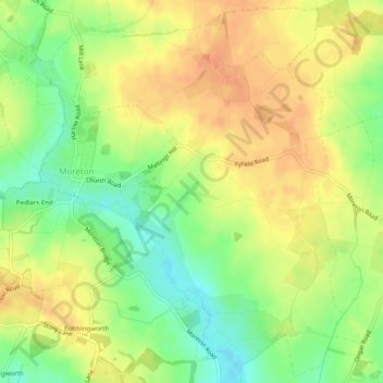
Name: Moreton topographic map, elevation, terrain.

Location: Moreton, Epping Forest, Essex, England, United Kingdom (51.72494 0.20447 51.75448 0.25381)

Average elevation: 70 m

Minimum elevation: 47 m

Maximum elevation: 87 m

Essex trails, hiking, mountain biking, running and outdoor activities

Gear up for your next adventure:

🧣Neck Gaiters - Versatile protection against wind and cold
🧢Waterproof Hiking Hats - Keep the rain off your face while studying topographic maps
👕Technical Hiking Tees - Moisture-management for high-exertion climbs
🎒Backpack Rain Covers - Universal waterproof covers to protect your gear from downpours
GPS Outdoor Watches - Watches with GPS tracking for hiking and exploration

As an Amazon Associate, this site earns from qualifying purchases at no extra cost to you.