
Make a donation
Gear up for your next adventure:
As an Amazon Associate, this site earns from qualifying purchases at no extra cost to you.
Clipper Mills topographic map
Click on the map to display elevation.
Make a donation
Gear up for your next adventure:
As an Amazon Associate, this site earns from qualifying purchases at no extra cost to you.
About this map
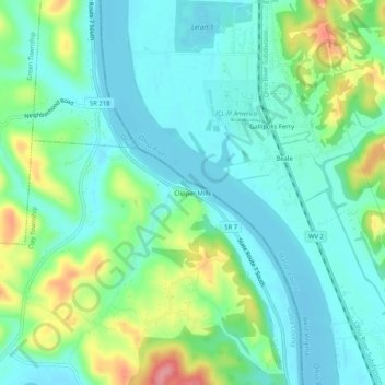
Name: Clipper Mills topographic map, elevation, terrain.
Average elevation: 191 m
Minimum elevation: 164 m
Maximum elevation: 263 m
Make a donation
Gear up for your next adventure:
As an Amazon Associate, this site earns from qualifying purchases at no extra cost to you.
Other topographic maps
Click on a map to view its topography, its elevation and its terrain.
Gallipolis
United States > Ohio > Gallia County
Winters are cold, with an average January temperature of 34.3 °F (1.3 °C). Snowfall is generally very light, with a mean average snowfall of 10.9 inches (280 mm). The village does not experience by lake-effect snow, although the village's weather can be influenced by the Great Lakes and regional topography.…
Average elevation: 203 m
Make a donation
Gear up for your next adventure:
As an Amazon Associate, this site earns from qualifying purchases at no extra cost to you.