Geolocate

Muscoda topographic map

Interactive map

Click on the map to display elevation.

About this map

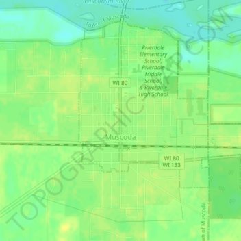
Name: Muscoda topographic map, elevation, terrain.

Location: Muscoda, Grant County, Wisconsin, United States (43.17606 -90.44947 43.19829 -90.41269)

Average elevation: 210 m

Minimum elevation: 199 m

Maximum elevation: 217 m

Other topographic maps

Click on a map to view its topography, its elevation and its terrain.

Town of Glen Haven

United States > Wisconsin > Grant County

Town of Glen Haven, Grant County, Wisconsin, 53810, United States

Average elevation: 262 m

Cassville

United States > Wisconsin > Grant County

Cassville, Grant County, Wisconsin, United States

Average elevation: 222 m

Town of Beetown

United States > Wisconsin > Grant County

Town of Beetown, Grant County, Wisconsin, 53802, United States

Average elevation: 281 m

Blue River

United States > Wisconsin > Grant County

Blue River, Grant County, Wisconsin, United States

Average elevation: 223 m