
Heath Hayes and Wimblebury topographic map
Interactive map
Click on the map to display elevation.
About this map
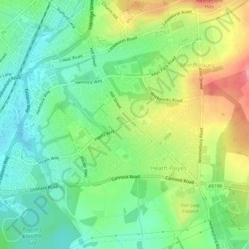
Name: Heath Hayes and Wimblebury topographic map, elevation, terrain.
Average elevation: 170 m
Minimum elevation: 136 m
Maximum elevation: 224 m
Other topographic maps
Click on a map to view its topography, its elevation and its terrain.
Wimblebury
United Kingdom > England > Cannock Chase > Wimblebury
Wimblebury, Cannock Chase, Staffordshire, West Midlands, England, WS12 2AB, United Kingdom
Average elevation: 184 m
Hednesford
United Kingdom > England > Cannock Chase > Hednesford
Hednesford, Staffordshire, West Midlands, England, WS12 4AH, United Kingdom
Average elevation: 167 m
Heath Hayes
United Kingdom > England > Cannock Chase > Heath Hayes
Heath Hayes, Cannock Chase, Staffordshire, West Midlands, England, WS12 3HE, United Kingdom
Average elevation: 170 m
Cannock Extension Canal
United Kingdom > England > Cannock Chase
Cannock Extension Canal, Cannock Chase, Staffordshire, West Midlands, England, WS3 5AW, United Kingdom
Average elevation: 145 m