
Coton Farm topographic map
Interactive map
Click on the map to display elevation.
About this map
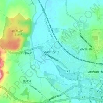
Name: Coton Farm topographic map, elevation, terrain.
Average elevation: 72 m
Minimum elevation: 52 m
Maximum elevation: 146 m
Other topographic maps
Click on a map to view its topography, its elevation and its terrain.
Tamworth Castle
United Kingdom > England > Staffordshire > Tamworth > Leyfields
Tamworth Castle, Market Street, Bolehall, Leyfields, Tamworth, Staffordshire, England, B79 7LD, United Kingdom
Average elevation: 65 m
Leyfields
United Kingdom > England > Staffordshire > Tamworth
Leyfields, Tamworth, Staffordshire, England, B79 8HS, United Kingdom
Average elevation: 66 m