Geolocate

Acropolis topographic map

Click on the map to display elevation.

About this map

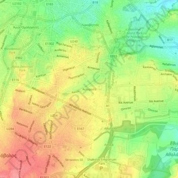
Name: Acropolis topographic map, elevation, terrain.

Location: Acropolis, Strovolos, Strovolos Municipality, Nicosia District, Cyprus, 2006, Cyprus (35.13292 33.34115 35.17292 33.38115)

Average elevation: 172 m

Minimum elevation: 133 m

Maximum elevation: 208 m

Gear up for your next adventure:

🪢Paracord - Multi-purpose cord for camping and survival
🥾Walking Shoes - Lightweight walking shoes for countryside and coastal paths
🧰First Aid Kits - Essential safety kits for outdoor activities
🧺Ultralight Dry Bags - Organize and waterproof your gear inside your rucksack
🧴Sport Sunscreen Sticks - High-protection sunblock that won't run into your eyes on the trail

As an Amazon Associate, this site earns from qualifying purchases at no extra cost to you.