
Thank you for supporting this site ❤️
Make a donation
Make a donation
Gear up for your next adventure:
As an Amazon Associate, this site earns from qualifying purchases at no extra cost to you.
Melezet topographic map
Click on the map to display elevation.
Thank you for supporting this site ❤️
Make a donation
Make a donation
Gear up for your next adventure:
As an Amazon Associate, this site earns from qualifying purchases at no extra cost to you.
About this map
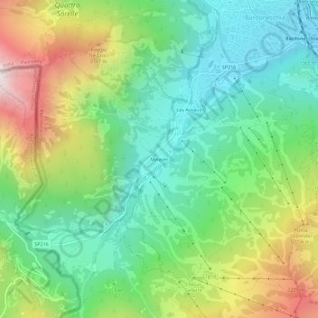
Name: Melezet topographic map, elevation, terrain.
Location: Melezet, Bardonecchia, Torino, Piemonte, 10052, Italia (45.04044 6.66432 45.08044 6.70432)
Average elevation: 1,689 m
Minimum elevation: 1,249 m
Maximum elevation: 2,526 m
Thank you for supporting this site ❤️
Make a donation
Make a donation
Gear up for your next adventure:
As an Amazon Associate, this site earns from qualifying purchases at no extra cost to you.