Geolocate

Calubian topographic map

Click on the map to display elevation.

About this map
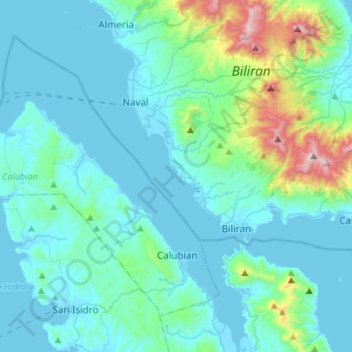
Name: Calubian topographic map, elevation, terrain.

Location: Calubian, Leyte 3rd District, Leyte, Eastern Visayas, 6534, Philippines (11.40082 124.19111 11.61172 124.46152)

Average elevation: 148 m

Minimum elevation: -1 m

Maximum elevation: 1,110 m

Other topographic maps

Click on a map to view its topography, its elevation and its terrain.
Tacloban

Philippines > Leyte > Tacloban

Average elevation: 29 m

Patag

Philippines > Leyte > Baybay

Average elevation: 64 m

Sea of Clouds

Philippines > Leyte > Baybay > Cuatro de Agosto

Average elevation: 187 m

Kabalasan

Philippines > Leyte > Baybay

Average elevation: 44 m

Concepcion

Philippines > Leyte > Ormoc

Average elevation: 89 m

Bulak

Philippines > Leyte > Abuyog > Bulak

Average elevation: 80 m

San Augustin

Philippines > Leyte > Babatngon

Average elevation: 10 m

Pangasugan

Philippines > Leyte > Baybay

Average elevation: 61 m

Mailhi

Philippines > Leyte > Baybay

Average elevation: 236 m

Manlawaan

Philippines > Leyte > Leyte

Average elevation: 79 m

Hilaan

Philippines > Leyte > Hilongos

Average elevation: 243 m

Mount Sacripante

Philippines > Leyte > Inopacan

Average elevation: 760 m

Odiongan

Philippines > Leyte > Abuyog

Average elevation: 15 m

Divisoria

Philippines > Leyte > Alangalang > Divisoria

Average elevation: 50 m

Busay

Philippines > Leyte > Barugo > Busay

Average elevation: 18 m

Gear up for your next adventure:

📕Outdoor Navigation Books - Learn traditional and modern navigation techniques
🥾Men's Waterproof Hiking Boots - Durable footwear with deep lugs for muddy and rocky UK terrains
👕Technical Hiking Tees - Moisture-management for high-exertion climbs
🔥Emergency Fire Starters - Reliable ignition tools for survival situations in damp conditions
👕Merino Base Layers - Natural temperature regulation for cold weather hiking and camping

As an Amazon Associate, this site earns from qualifying purchases at no extra cost to you.