Geolocate

Gatineau topographic map

Interactive map

Click on the map to display elevation.

Gatineau

Gatineau is located in southwestern Quebec, on the northern bank of the Gatineau River. It is situated at an elevation of around 50 m (164.042 ft) The Gatineau Hills are the foothills of the Laurentian Mountains and located in the region. It is also the location of the second largest urban park in the world. They supply great skiing and snowboarding opportunities within minutes of the city. Gatineau is situated close to where the Canadian shield and the Saint Lawrence Lowlands intersect. The area has several major fault lines and small earthquakes do occur somewhat regularly, on average, there are at least one earthquake of intensity III or higher once every three years in Ottawa-Gatineau. The most memorable being the 2010 Central Canada earthquake that occurred in Quebec. The epicentre was situated approximately 56 kilometres (35 mi) north of Ottawa, Ontario, in the municipality of Val-des-Bois, Quebec.

Wikipedia (CC-BY-SA 3.0)

About this map

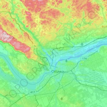
Name: Gatineau topographic map, elevation, terrain.

Location: Gatineau, Outaouais, Quebec, Canada (45.37238 -75.90835 45.59912 -75.34423)

Average elevation: 127 m

Minimum elevation: 39 m

Maximum elevation: 409 m

Other topographic maps

Click on a map to view its topography, its elevation and its terrain.

Iron Hill

Canada > Quebec > Brome-Missisquoi > Lac-Brome

Average elevation: 245 m

Danford Lake

Canada > Quebec > Pontiac > Alleyn-et-Cawood

Average elevation: 210 m

Val-d'Espoir

Canada > Quebec > Le Rocher-Percé > Percé

Average elevation: 136 m

Lac Farmer

Canada > Quebec > Les Pays-d'en-Haut > Wentworth-Nord

Average elevation: 329 m

Lac Manon

Canada > Quebec > Le Fjord-du-Saguenay > Mont-Valin

Average elevation: 558 m

Languedoc

Canada > Quebec > Abitibi-Ouest > Rivière-Ojima

Average elevation: 308 m

Leggatt

Canada > Quebec > La Mitis > Grand-Métis

Average elevation: 61 m

Black and White

Canada > Quebec > Les Laurentides > Montcalm

Average elevation: 297 m

Lac Doré

Canada > Quebec > La Haute-Côte-Nord > Lac-au-Brochet

Average elevation: 585 m

Lac Xavier

Canada > Quebec > Les Laurentides > La Conception

Average elevation: 295 m

Lac Lili

Canada > Quebec > Matawinie > Chertsey

Average elevation: 353 m

The Edge

Canada > Quebec > Les Laurentides > Mont-Tremblant

Average elevation: 687 m

Lac Frime

Canada > Quebec > Antoine-Labelle > Lac-Marguerite

Average elevation: 245 m

Île de l'Est

Canada > Quebec > Eeyou Istchee

Average elevation: 377 m

Île aux Cochons

Canada > Quebec > Abitibi-Ouest > Duparquet

Average elevation: 301 m

Sainte-Julie-Station

Canada > Quebec > L'Érable > Laurierville

Average elevation: 147 m

Lac Besson

Canada > Quebec > Les Laurentides > Montcalm

Average elevation: 361 m

Mansonville

Canada > Quebec > Memphrémagog > Potton

Average elevation: 211 m

Battlefield Park

Canada > Quebec > Quebec City

Average elevation: 38 m

Mount Loyal

Canada > Quebec > Matawinie > Rawdon

Average elevation: 220 m

Mont des Pins

Canada > Quebec > Papineau > Namur

Average elevation: 251 m

Rivière-du-Loup

Canada > Quebec > Rivière-du-Loup

Average elevation: 83 m

Rouyn-Noranda

Canada > Quebec > Rouyn-Noranda > Rouyn-Noranda

Average elevation: 305 m

Sept-Îles

Canada > Quebec > Sept-Rivières > Sept-Îles

Average elevation: 65 m

Knowlton

Canada > Quebec > Lac-Brome > Knowlton

Average elevation: 234 m

Shawinigan

Canada > Quebec > Shawinigan

Average elevation: 139 m

Lac-David

Canada > Quebec > Matawinie > Chertsey > Lac-David

Average elevation: 368 m

Les Sources

Canada > Quebec

Average elevation: 284 m

Manicouagan

Canada > Quebec

Average elevation: 496 m

Acton

Canada > Quebec

Average elevation: 151 m

Cap Martin

Canada > Quebec > Saint-Urbain

Average elevation: 186 m

Sherbrooke

Canada > Quebec > Sherbrooke

Average elevation: 249 m

Barnston

Canada > Quebec > Coaticook (MRC) > Coaticook

Average elevation: 418 m

Farmborough

Canada > Quebec > Rouyn-Noranda

Average elevation: 290 m

Lac-de-l'Est

Canada > Quebec > Lac-de-l'Est

Average elevation: 421 m

Parc Lady-Alys-Robi

Canada > Quebec > Montreal

Average elevation: 43 m

Rivière Port Joli

Canada > Quebec > Sainte-Louise

Average elevation: 230 m

Parc de la Mauricie

Canada > Quebec > Laval

Average elevation: 33 m

Parc Émilie-Gamelin

Canada > Quebec > Montreal

Average elevation: 33 m

Lac Frime

Canada > Quebec > Antoine-Labelle > Lac-Marguerite

Average elevation: 246 m

Charteris

Canada > Quebec > Clarendon > Charteris

Average elevation: 178 m

Le Morne

Canada > Quebec > Sainte-Rose-de-Watford

Average elevation: 365 m

AWOS

Canada > Quebec > Longueuil

Average elevation: 27 m

Covey Hill

Canada > Quebec > Havelock

Average elevation: 283 m

Gaspésie

Canada > Quebec > Mont-Albert

Average elevation: 459 m

Lac Brunet

Canada > Quebec > La Tuque

Average elevation: 295 m

Colonie-Cinq

Canada > Quebec > Rouyn-Noranda > Cléricy

Average elevation: 282 m

Guyenne

Canada > Quebec > Abitibi > Lac-Chicobi > Guyenne

Average elevation: 314 m

Lac Belec

Canada > Quebec > Le Domaine-du-Roy > Lac-Ashuapmushuan

Average elevation: 434 m