
Make a donation
Gear up for your next adventure:
As an Amazon Associate, this site earns from qualifying purchases at no extra cost to you.
Barbacena topographic map
Click on the map to display elevation.
Make a donation
Gear up for your next adventure:
As an Amazon Associate, this site earns from qualifying purchases at no extra cost to you.
Barbacena
It is in the foothills of the Serra da Mantiqueira south of the state capital Belo Horizonte at an elevation of 1,136 m (3,727 ft), making it one of the ten highest cities in Brazil. Located on the important BR-040 highway (also called Rodovia JK), which links Brasília to Rio de Janeiro, it is 165 km (103 mi) from the state capital and 97 km (60 mi) from Juiz de Fora.
Make a donation
Gear up for your next adventure:
As an Amazon Associate, this site earns from qualifying purchases at no extra cost to you.
About this map
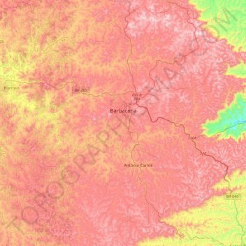
Name: Barbacena topographic map, elevation, terrain.
Average elevation: 1,077 m
Minimum elevation: 619 m
Maximum elevation: 1,346 m
Make a donation
Gear up for your next adventure:
As an Amazon Associate, this site earns from qualifying purchases at no extra cost to you.
Other topographic maps
Click on a map to view its topography, its elevation and its terrain.
Make a donation
Gear up for your next adventure:
As an Amazon Associate, this site earns from qualifying purchases at no extra cost to you.