Geolocate

Kilquade topographic map

Click on the map to display elevation.

About this map
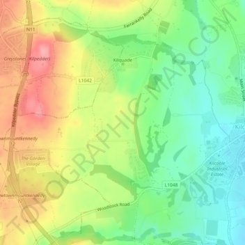
Name: Kilquade topographic map, elevation, terrain.

Location: Kilquade, Kilcoole ED, The Municipal District of Greystones, County Wicklow, Leinster, Ireland (53.09674 -6.09469 53.11496 -6.07717)

Average elevation: 61 m

Minimum elevation: 14 m

Maximum elevation: 119 m

Other topographic maps

Click on a map to view its topography, its elevation and its terrain.
Greystones

Ireland > County Wicklow > Greystones

Average elevation: 49 m

Bray Head

Ireland > County Wicklow

Average elevation: 44 m

Kilbride

Ireland > County Wicklow

Average elevation: 232 m

Rathdrum

Ireland > County Wicklow > Rathdrum

Average elevation: 155 m

Luggala

Ireland > County Wicklow

Average elevation: 386 m

Lough Tay

Ireland > County Wicklow

Average elevation: 395 m

Annamoe

Ireland > County Wicklow

Average elevation: 231 m

Ballyknockan

Ireland > County Wicklow

Average elevation: 309 m

Vartry Reservoir Lower

Ireland > County Wicklow

Average elevation: 229 m

Mullaghcleevaun

Ireland > County Wicklow

Average elevation: 654 m

Ashford

Ireland > County Wicklow > Ashford

Average elevation: 50 m

Gear up for your next adventure:

🔪Outdoor Multi-Tools - Versatile tools for gear repairs and food prep in the wild
🛌Insulated Sleeping Mats - Crucial thermal protection when sleeping on cold, uneven ground
⛺Lightweight Tents - Compact tents for backpacking and trekking
👟Waterproof Leg Gaiters - Keep mud and water out of your boots in boggy terrain
🧘Folding Sit Mats - Dry and warm seat for map-reading breaks on damp ground

As an Amazon Associate, this site earns from qualifying purchases at no extra cost to you.