
La Croix-Saint-Leufroy topographic map
Interactive map
Click on the map to display elevation.
About this map
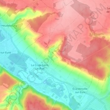
Name: La Croix-Saint-Leufroy topographic map, elevation, terrain.
Average elevation: 92 m
Minimum elevation: 20 m
Maximum elevation: 162 m
Other topographic maps
Click on a map to view its topography, its elevation and its terrain.
Crèvecœur
France > Normandie > Eure > Clef-Vallée-d'Eure
Crèvecœur, La Croix-Saint-Leufroy, Clef-Vallée-d'Eure, Les Andelys, Eure, Normandie, France métropolitaine, 27490, France
Average elevation: 77 m