
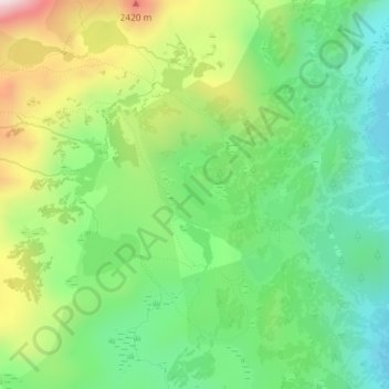
Lac de la Coumasse topographic map
Interactive map
Click on the map to display elevation.
About this map
Name: Lac de la Coumasse topographic map, elevation, terrain.
Average elevation: 2,189 m
Minimum elevation: 1,999 m
Maximum elevation: 2,522 m
Other topographic maps
Click on a map to view its topography, its elevation and its terrain.
Estany del Castellar
France > Occitanie > Angoustrine-Villeneuve-des-Escaldes
Estany del Castellar, GR 10, Angoustrine-Villeneuve-des-Escaldes, Prades, Pyrénées-Orientales, Occitanie, France métropolitaine, 66760, France
Average elevation: 2,318 m