
Hohenburg topographic map
Interactive map
Click on the map to display elevation.
About this map
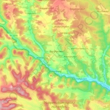
Name: Hohenburg topographic map, elevation, terrain.
Location: Hohenburg, Landkreis Amberg-Sulzbach, Bavaria, 92277, Germany (49.27916 11.72177 49.34238 11.88455)
Average elevation: 472 m
Minimum elevation: 360 m
Maximum elevation: 602 m
Other topographic maps
Click on a map to view its topography, its elevation and its terrain.
Bergstein
Germany > Bavaria > Landkreis Amberg-Sulzbach > Illschwang
Bergstein, Illschwang, Illschwang (VGem), Landkreis Amberg-Sulzbach, Bavaria, 92278, Germany
Average elevation: 548 m
Vilseck
Germany > Bavaria > Landkreis Amberg-Sulzbach
Vilseck, Landkreis Amberg-Sulzbach, Bavaria, 92249, Germany
Average elevation: 443 m
Schmidmühlen
Germany > Bavaria > Landkreis Amberg-Sulzbach
Schmidmühlen, Landkreis Amberg-Sulzbach, Bavaria, 92287, Germany
Average elevation: 431 m