
Make a donation
Gear up for your next adventure:
As an Amazon Associate, this site earns from qualifying purchases at no extra cost to you.
Fort Kent Mills topographic map
Click on the map to display elevation.
Make a donation
Gear up for your next adventure:
As an Amazon Associate, this site earns from qualifying purchases at no extra cost to you.
About this map
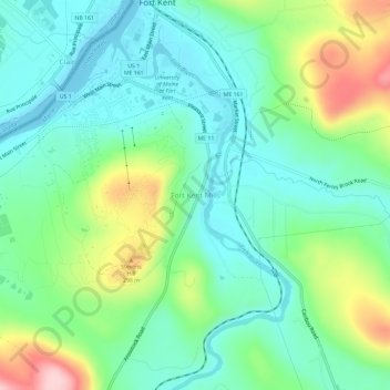
Name: Fort Kent Mills topographic map, elevation, terrain.
Average elevation: 213 m
Minimum elevation: 149 m
Maximum elevation: 367 m
Make a donation
Gear up for your next adventure:
As an Amazon Associate, this site earns from qualifying purchases at no extra cost to you.
Other topographic maps
Click on a map to view its topography, its elevation and its terrain.
Saint John River
United States > Maine > Aroostook County > Fort Kent
When the Europeans arrived into Wolastokuk, the homeland of the Maliseet Nation and Saint John River basin, they found the locals hunting, gathering, and farming near the banks of the river. European colonists may have used fields and town sites prepared by the natives. Archaeological evidence is that the…
Average elevation: 208 m