
Rajac topographic map
Interactive map
Click on the map to display elevation.
About this map
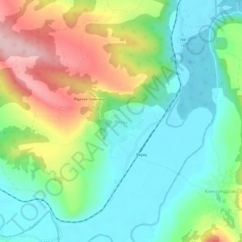
Name: Rajac topographic map, elevation, terrain.
Average elevation: 127 m
Minimum elevation: 48 m
Maximum elevation: 279 m
Other topographic maps
Click on a map to view its topography, its elevation and its terrain.
Dusanovac
Serbia > Central Serbia > Bor Administrative District > Negotin Municipality
Average elevation: 91 m
Negotin
Serbia > Central Serbia > Bor Administrative District > Negotin Municipality
Average elevation: 86 m
Prahovo
Serbia > Central Serbia > Bor Administrative District > Negotin Municipality
Average elevation: 48 m