Geolocate

Marshall topographic map

Click on the map to display elevation.

About this map

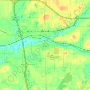
Name: Marshall topographic map, elevation, terrain.

Location: Marshall, Calhoun County, Michigan, 49068, United States (42.22481 -84.99069 42.29682 -84.92427)

Average elevation: 283 m

Minimum elevation: 266 m

Maximum elevation: 301 m

Other topographic maps

Click on a map to view its topography, its elevation and its terrain.

Gear up for your next adventure:

🧢Thermal Beanie Hats - Prevent heat loss from the head in windy summit conditions
🪢Paracord - Multi-purpose cord for camping and survival
🧣Neck Gaiters - Protects against wind and sun on exposed ridges and peaks
🛰️Outdoor GPS Navigation - Navigation devices for remote and off-grid areas
🐕Dog Hiking Gear - Equipment for hiking safely with dogs

As an Amazon Associate, this site earns from qualifying purchases at no extra cost to you.