
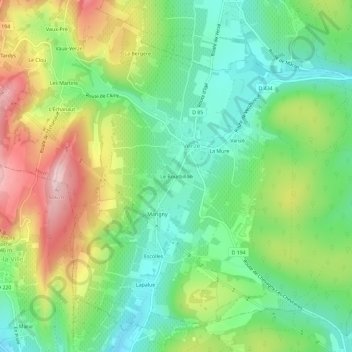
Le Bourbillon topographic map
Interactive map
Click on the map to display elevation.
About this map
Name: Le Bourbillon topographic map, elevation, terrain.
Average elevation: 342 m
Minimum elevation: 245 m
Maximum elevation: 498 m
Other topographic maps
Click on a map to view its topography, its elevation and its terrain.
Vaux-Verzé
France > Bourgogne-Franche-Comté > Saône-et-Loire > Verzé
Vaux-Verzé, Verzé, Mâcon, Saône-et-Loire, Bourgogne-Franche-Comté, France métropolitaine, 71960, France
Average elevation: 384 m
Verchizeuil
France > Bourgogne-Franche-Comté > Saône-et-Loire > Verzé
Verchizeuil, Verzé, Mâcon, Saône-et-Loire, Bourgogne-Franche-Comté, France métropolitaine, 71960, France
Average elevation: 293 m
Les Tardys
France > Bourgogne-Franche-Comté > Saône-et-Loire > Verzé
Les Tardys, Verzé, Mâcon, Saône-et-Loire, Bourgogne-Franche-Comté, France métropolitaine, 71960, France
Average elevation: 403 m