
Make a donation
Gear up for your next adventure:
As an Amazon Associate, this site earns from qualifying purchases at no extra cost to you.
Republika Srpska topographic map
Click on the map to display elevation.
Make a donation
Gear up for your next adventure:
As an Amazon Associate, this site earns from qualifying purchases at no extra cost to you.
Republika Srpska
Republika Srpska covers 24,816.2 square kilometres (9,582 square miles), excluding the Brčko District, which is held in condominium by both entities, but is de facto sovereign within Bosnia and Herzegovina. Republika Srpska, if it were a country, would be 146th largest in the world. Elevation varies greatly, with Maglić, a peak in the Dinaric Alps near Montenegro, reaching 2,386 metres (7,828 ft), and parts nearer the Adriatic going down to sea level. The largest and most popular ski resort in Bosnia and Herzegovina is situated on the slopes of the mountain Jahorina, in the eastern part of the entity. Other major mountains in Republika Srpska include Volujak, Zelengora, Lelija, Lebršnik, Crvanj, Orjen, Klekovača, Vitorog, Kozara, Romanija, Treskavica and Trebević.
Make a donation
Gear up for your next adventure:
As an Amazon Associate, this site earns from qualifying purchases at no extra cost to you.
About this map
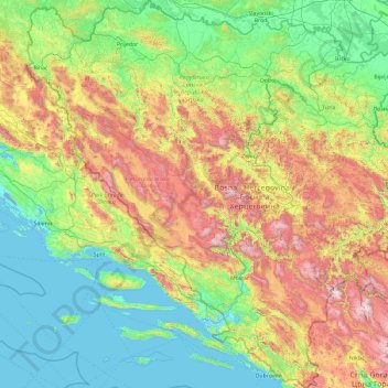
Name: Republika Srpska topographic map, elevation, terrain.
Location: Republika Srpska, Bosnia and Herzegovina (42.55531 16.20013 45.27641 19.62373)
Average elevation: 522 m
Minimum elevation: -4 m
Maximum elevation: 2,306 m
Make a donation
Gear up for your next adventure:
As an Amazon Associate, this site earns from qualifying purchases at no extra cost to you.
Other topographic maps
Click on a map to view its topography, its elevation and its terrain.
Mosor
Bosnia and Herzegovina > Federation of Bosnia and Herzegovina > City of Široki Brijeg > Gostuša
Average elevation: 633 m
Gračanica
Bosnia and Herzegovina > Federation of Bosnia and Herzegovina > Town of Gračanica
Average elevation: 267 m
Džanani
Bosnia and Herzegovina > Federation of Bosnia and Herzegovina > City of Cazin > Šturlić
Average elevation: 345 m
Make a donation
Gear up for your next adventure:
As an Amazon Associate, this site earns from qualifying purchases at no extra cost to you.
Make a donation
Gear up for your next adventure:
As an Amazon Associate, this site earns from qualifying purchases at no extra cost to you.
Kupres
Bosnia and Herzegovina > Federation of Bosnia and Herzegovina
Kupres is located at an altitude between 1,120 and 1,250 m (3,675 and 4,101 ft) and averages 55 days a year of snowfall due to its advantageous location in the Dinaric Alps.
Average elevation: 1,254 m
Tuzla
Bosnia and Herzegovina > Federation of Bosnia and Herzegovina > City of Tuzla
Average elevation: 349 m
Bugojno
Bosnia and Herzegovina > Federation of Bosnia and Herzegovina
The municipality has an average elevation of 570 metres above sea level. Much of its 366 km2 is forested. The terrain is mountainous with several prominent features. Stožer (1662m), Kalin (1,530m) and Rudina (1,385m) are the tallest mountains in Bugojno.
Average elevation: 647 m
Make a donation
Gear up for your next adventure:
As an Amazon Associate, this site earns from qualifying purchases at no extra cost to you.
Zenica
Bosnia and Herzegovina > Federation of Bosnia and Herzegovina > City of Zenica
The city is geographically located in the heart of Bosnia. The settled area is 43.01 km2 (16.61 sq mi) and of the city proper covers 558.5 km2 (215.6 sq mi). Elevation is 310–350 m (1,017–1,148 ft). The rivers Bosna, Lašva, Babina, and Kočeva flow through the settlement. A moderate continental climate…
Average elevation: 730 m
Kraljeva Sutjeska
Bosnia and Herzegovina > Federation of Bosnia and Herzegovina
Average elevation: 695 m
Cazin
Bosnia and Herzegovina > Federation of Bosnia and Herzegovina > City of Cazin
Average elevation: 375 m
Make a donation
Gear up for your next adventure:
As an Amazon Associate, this site earns from qualifying purchases at no extra cost to you.
Posušje
Bosnia and Herzegovina > Federation of Bosnia and Herzegovina
It lies in the Posuško polje, at an altitude of 675 m, at the intersection of the road from Split and Imotski in Croatia towards Tomislavgrad and Mostar.
Average elevation: 752 m
Visoko
Bosnia and Herzegovina > Federation of Bosnia and Herzegovina > Grad Visoko
The Visoko municipality covers 232 square kilometres with several characteristic, morphologically distinctive valleys formed by the foothills of the Central Bosnian mountains including Ozren, Vranica and Zvijezda. The altitude of the region ranges from 400 to 1,050 metres. Visoko's natural environment is…
Average elevation: 527 m
Make a donation
Gear up for your next adventure:
As an Amazon Associate, this site earns from qualifying purchases at no extra cost to you.
Visoko
Bosnia and Herzegovina > Federation of Bosnia and Herzegovina > Grad Visoko
The Visoko municipality covers 232 square kilometres with several characteristic, morphologically distinctive valleys formed by the foothills of the Central Bosnian mountains including Ozren, Vranica and Zvijezda. The altitude of the region ranges from 400 to 1,050 metres. Visoko's natural environment is…
Average elevation: 527 m
Jahorina
Bosnia and Herzegovina > Republika Srpska > City of Istočno Sarajevo
Jahorina (Serbian Cyrillic: Јахорина, pronounced [jâxɔrina]) is a mountain in Bosnia and Herzegovina, located at the tripoint of the municipalities of Pale, Trnovo, Republika Srpska and Trnovo, Federation of Bosnia and Herzegovina. Part of the Dinaric Alps, it borders Mount Trebević. Its highest…
Average elevation: 1,131 m
Make a donation
Gear up for your next adventure:
As an Amazon Associate, this site earns from qualifying purchases at no extra cost to you.
Greb
Bosnia and Herzegovina > Federation of Bosnia and Herzegovina > Markovići
Average elevation: 981 m
Banjani
Bosnia and Herzegovina > Federation of Bosnia and Herzegovina > Town of Bosanska Krupa
Average elevation: 308 m
Make a donation
Gear up for your next adventure:
As an Amazon Associate, this site earns from qualifying purchases at no extra cost to you.
Tuzla
Bosnia and Herzegovina > Federation of Bosnia and Herzegovina > City of Tuzla
Average elevation: 349 m
Vrbljani
Bosnia and Herzegovina > Federation of Bosnia and Herzegovina > Town of Konjic
Average elevation: 727 m
Make a donation
Gear up for your next adventure:
As an Amazon Associate, this site earns from qualifying purchases at no extra cost to you.
Gudelji
Bosnia and Herzegovina > Federation of Bosnia and Herzegovina > Jazvine
Average elevation: 472 m
Brđani
Bosnia and Herzegovina > Federation of Bosnia and Herzegovina > City of Tuzla
Average elevation: 370 m
Make a donation
Gear up for your next adventure:
As an Amazon Associate, this site earns from qualifying purchases at no extra cost to you.
Gornja Bukovica
Bosnia and Herzegovina > Federation of Bosnia and Herzegovina
Average elevation: 492 m
Lukavac
Bosnia and Herzegovina > Federation of Bosnia and Herzegovina > Town of Lukavac
Average elevation: 222 m
Plane
Bosnia and Herzegovina > Federation of Bosnia and Herzegovina > City of Tuzla
Average elevation: 240 m
Moravci
Bosnia and Herzegovina > Republika Srpska > Town of Prnjavor > Šarinci
Average elevation: 232 m
Make a donation
Gear up for your next adventure:
As an Amazon Associate, this site earns from qualifying purchases at no extra cost to you.
Teslić
Bosnia and Herzegovina > Republika Srpska
The municipality of Teslić is located in the northern part of Central Bosnia, encompassing the southern part of the western half of the Republic of Srpska. With a territory of 846 km², it ranks among the largest municipalities in the Republic of Srpska. It borders the municipalities of Doboj, Tešanj,…
Average elevation: 278 m
Han Pijesak
Bosnia and Herzegovina > Republika Srpska
Han Pijesak is located about 70km northeast from Sarajevo, on the slopes of mountain Romanija, at an altitude of 1,100m.
Average elevation: 1,092 m
Make a donation
Gear up for your next adventure:
As an Amazon Associate, this site earns from qualifying purchases at no extra cost to you.
Podorašac
Bosnia and Herzegovina > Federation of Bosnia and Herzegovina > Town of Konjic
Average elevation: 641 m
Vareš
Bosnia and Herzegovina > Federation of Bosnia and Herzegovina
The Vareš region also has possibilities for winter tourism development. Due to its position and elevation snow stays longer than in other regions, and the beautiful areas surrounding it are really good for skiing and skating. The mountain resort Doli is located on Zvijezda Mountain.
Average elevation: 1,091 m
Brgule
Bosnia and Herzegovina > Federation of Bosnia and Herzegovina > City of Tuzla
Average elevation: 265 m
Make a donation
Gear up for your next adventure:
As an Amazon Associate, this site earns from qualifying purchases at no extra cost to you.
Prnjavor
Bosnia and Herzegovina > Republika Srpska > Town of Prnjavor
The municipality is located in the basin of the Ukrina river and is characterized by a mostly lowland hilly terrain configuration with the highest peak of 594m (mountain Ljubić). The Municipality of Prnjavor is shielded on all sides by low mountains such as Ljubić (south) and Motajica (north). The town of…
Average elevation: 180 m
Livno
Bosnia and Herzegovina > Federation of Bosnia and Herzegovina > City of Livno
Average elevation: 907 m
Make a donation
Gear up for your next adventure:
As an Amazon Associate, this site earns from qualifying purchases at no extra cost to you.
Dinaric Alps
Bosnia and Herzegovina > Federation of Bosnia and Herzegovina > City of Livno
Average elevation: 1,599 m
Make a donation
Gear up for your next adventure:
As an Amazon Associate, this site earns from qualifying purchases at no extra cost to you.
Ravna planina
Bosnia and Herzegovina > Republika Srpska > City of Istočno Sarajevo > Gornje Pale
Average elevation: 1,265 m
Tuzla
Bosnia and Herzegovina > Federation of Bosnia and Herzegovina > City of Tuzla
Average elevation: 349 m
Čapljina
Bosnia and Herzegovina > Federation of Bosnia and Herzegovina > City of Čapljina
Average elevation: 98 m
Make a donation
Gear up for your next adventure:
As an Amazon Associate, this site earns from qualifying purchases at no extra cost to you.
Una
Bosnia and Herzegovina > Federation of Bosnia and Herzegovina > City of Bihać > Bihać
Average elevation: 255 m
Una
Bosnia and Herzegovina > Federation of Bosnia and Herzegovina > City of Bihać > Bihać
Average elevation: 255 m
Make a donation
Gear up for your next adventure:
As an Amazon Associate, this site earns from qualifying purchases at no extra cost to you.
Brgule
Bosnia and Herzegovina > Federation of Bosnia and Herzegovina > City of Tuzla
Average elevation: 265 m
Make a donation
Gear up for your next adventure:
As an Amazon Associate, this site earns from qualifying purchases at no extra cost to you.
Brgule
Bosnia and Herzegovina > Federation of Bosnia and Herzegovina > City of Tuzla
Average elevation: 265 m
Jahorina
Bosnia and Herzegovina > Republika Srpska > City of Istočno Sarajevo
Jahorina (Serbian Cyrillic: Јахорина, pronounced [jâxɔrina]) is a mountain in Bosnia and Herzegovina, located at the tripoint of the municipalities of Pale, Trnovo, Republika Srpska and Trnovo, Federation of Bosnia and Herzegovina. Part of the Dinaric Alps, it borders Mount Trebević. Its highest…
Average elevation: 1,131 m
Make a donation
Gear up for your next adventure:
As an Amazon Associate, this site earns from qualifying purchases at no extra cost to you.
Tukovi
Bosnia and Herzegovina > Federation of Bosnia and Herzegovina > City of Bihać
Average elevation: 831 m
Make a donation
Gear up for your next adventure:
As an Amazon Associate, this site earns from qualifying purchases at no extra cost to you.
Visoko
Bosnia and Herzegovina > Federation of Bosnia and Herzegovina > Grad Visoko
The Visoko municipality covers 232 square kilometres with several characteristic, morphologically distinctive valleys formed by the foothills of the Central Bosnian mountains including Ozren, Vranica and Zvijezda. The altitude of the region ranges from 400 to 1,050 metres. Visoko's natural environment is…
Average elevation: 527 m
Make a donation
Gear up for your next adventure:
As an Amazon Associate, this site earns from qualifying purchases at no extra cost to you.
Mrkovići
Bosnia and Herzegovina > Federation of Bosnia and Herzegovina > City of Sarajevo
Average elevation: 938 m
Make a donation
Gear up for your next adventure:
As an Amazon Associate, this site earns from qualifying purchases at no extra cost to you.
Tatarevina
Bosnia and Herzegovina > Republika Srpska > Town of Prnjavor > Doline
Average elevation: 172 m
Dinaric Alps
Bosnia and Herzegovina > Federation of Bosnia and Herzegovina > City of Livno
Average elevation: 1,599 m
Make a donation
Gear up for your next adventure:
As an Amazon Associate, this site earns from qualifying purchases at no extra cost to you.
Dubovo brdo
Bosnia and Herzegovina > Federation of Bosnia and Herzegovina > City of Čapljina > Trebižat
Average elevation: 149 m
Make a donation
Gear up for your next adventure:
As an Amazon Associate, this site earns from qualifying purchases at no extra cost to you.
Donje Vukovsko
Bosnia and Herzegovina > Federation of Bosnia and Herzegovina
Average elevation: 1,241 m
Mošćanica
Bosnia and Herzegovina > Federation of Bosnia and Herzegovina > City of Zenica
Average elevation: 645 m
Drvar
Bosnia and Herzegovina > Federation of Bosnia and Herzegovina
This extremely hilly region, comprising the town of Drvar and the numerous outlying villages, covers approximately 1,030 square kilometres (400 square miles). The town is mainly situated on the left side of the River Unac, and its elevation is approximately 480 meters (1,574 feet).
Average elevation: 692 m
Make a donation
Gear up for your next adventure:
As an Amazon Associate, this site earns from qualifying purchases at no extra cost to you.
Make a donation
Gear up for your next adventure:
As an Amazon Associate, this site earns from qualifying purchases at no extra cost to you.