
Thank you for supporting this site ❤️
Make a donation
Make a donation
Gear up for your next adventure:
As an Amazon Associate, this site earns from qualifying purchases at no extra cost to you.
Chevril topographic map
Click on the map to display elevation.
Thank you for supporting this site ❤️
Make a donation
Make a donation
Gear up for your next adventure:
As an Amazon Associate, this site earns from qualifying purchases at no extra cost to you.
About this map
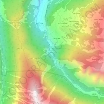
Name: Chevril topographic map, elevation, terrain.
Location: Chevril, Aymavilles, Aosta Valley, 11010, Italy (45.64617 7.20999 45.68617 7.24999)
Average elevation: 1,428 m
Minimum elevation: 757 m
Maximum elevation: 2,249 m
Thank you for supporting this site ❤️
Make a donation
Make a donation
Gear up for your next adventure:
As an Amazon Associate, this site earns from qualifying purchases at no extra cost to you.