
San Francesco topographic map
Interactive map
Click on the map to display elevation.
About this map
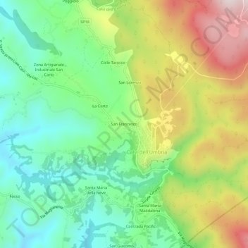
Name: San Francesco topographic map, elevation, terrain.
Location: San Francesco, Calvi dell'Umbria, Terni, Umbria, 05032, Italia (42.38763 12.54242 42.42763 12.58242)
Average elevation: 354 m
Minimum elevation: 135 m
Maximum elevation: 707 m
Other topographic maps
Click on a map to view its topography, its elevation and its terrain.
Zona Artigianale Industriale San Carlo
Italia > Umbria > Terni > Calvi dell'Umbria > Zona Artigianale Industriale San Carlo
Zona Artigianale Industriale San Carlo, Calvi dell'Umbria, Terni, Umbria, 05032, Italia
Average elevation: 279 m