
Jyrgalan topographic map
Interactive map
Click on the map to display elevation.
About this map
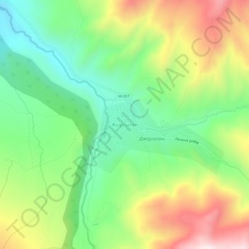
Name: Jyrgalan topographic map, elevation, terrain.
Average elevation: 2,397 m
Minimum elevation: 2,135 m
Maximum elevation: 2,792 m
Other topographic maps
Click on a map to view its topography, its elevation and its terrain.
Khan Tengri
Kyrgyzstan > Issyk-Kul Region > Ak-Suu District
Khan Tengri is a mountain of the Tian Shan mountain range in Central Asia. It is on the China—Kyrgyzstan—Kazakhstan tripoint, east of lake Issyk Kul. Its geologic elevation is 6,995 m (22,949 ft), but its glacial icecap rises to 7,010 m (22,999 ft). For this reason, in mountaineering circles, including for…
Average elevation: 5,894 m
Jengish Chokusu
Kyrgyzstan > Issyk-Kul Region > Ak-Suu District
Jengish Chokusu or Victory Peak is the highest mountain in the Tian Shan mountain system in Central Asia at 7,439 metres (24,406 ft). It lies on the China–Kyrgyzstan border between the Ak-Suu District in the Issyk-Kul Region of far Eastern Kyrgyzstan and Wensu County, Xinjiang, China. It is part of the…
Average elevation: 6,681 m