
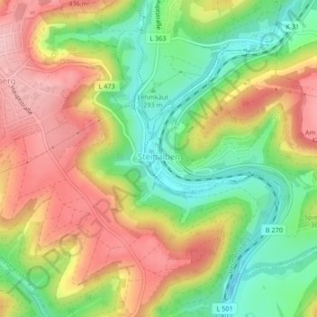
Steinalben topographic map
Interactive map
Click on the map to display elevation.
About this map
Name: Steinalben topographic map, elevation, terrain.
Average elevation: 338 m
Minimum elevation: 250 m
Maximum elevation: 430 m
Der Ort liegt am Übergang der Sickinger Höhe zum Pfälzischen Holzland im Tal der Moosalb innerhalb des Pfälzerwaldes. Im Norden befindet sich Horbach, im Osten Geiselberg, südlich liegt Waldfischbach-Burgalben und westlich Hermersberg.
Other topographic maps
Click on a map to view its topography, its elevation and its terrain.
Monbijou
Deutschland > Rheinland-Pfalz > Südwestpfalz > Dietrichingen
Monbijou, Dietrichingen, Zweibrücken-Land, Südwestpfalz, Rheinland-Pfalz, 66484, Deutschland
Average elevation: 291 m
Wiesbach
Deutschland > Rheinland-Pfalz > Südwestpfalz
Wiesbach, Zweibrücken-Land, Südwestpfalz, Rheinland-Pfalz, Deutschland
Average elevation: 331 m