
Rupandehi topographic map
Interactive map
Click on the map to display elevation.
Rupandehi
The district lies on the southern and western part of Nepal. On the East it shares border with Nawalparasi District, on West with Kapilvastu District, on North with Palpa District and on South with India. The elevation of the district lies between 100m to 1229m from sea level. The total area of the district is 1,360 km2 with 16.1% in Churia Range and rest in the Terai region.
About this map
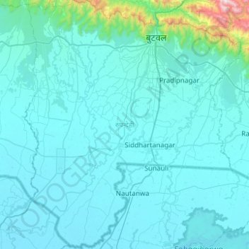
Name: Rupandehi topographic map, elevation, terrain.
Location: Rupandehi, Lumbini Province, Nepal (27.33016 83.20425 27.76729 83.63440)
Average elevation: 182 m
Minimum elevation: 86 m
Maximum elevation: 1,800 m
Other topographic maps
Click on a map to view its topography, its elevation and its terrain.
Arghakhanchi
Arghakhanchi lies between 27'45"N and 28'6"N latitude, and 80'45"E to 83'23"E longitude. It covers 1,193 km2. The altitude of the district varies from 305 to 2515 meter above the sea level. 68% of the district is in the mountainous Mahabharat Range and the rest is in the Siwalik Hills. Elevations range from…
Average elevation: 962 m
Dang
The Dudhwas rise steeply to a crest at about 700 meters, then slope more gradually into the Deukhuri Valley, down to 250 meters elevation at the Rapti River. The Dudhwas extend more than 100 km, causing the Rapti to detour west around them before turning southeast down the main trend of the plains into India.…
Average elevation: 746 m