Geolocate

Berneck topographic map

Interactive map

Click on the map to display elevation.

About this map

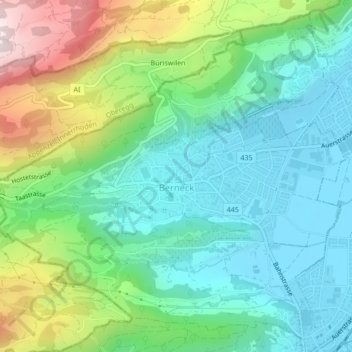
Name: Berneck topographic map, elevation, terrain.

Location: Berneck, Wahlkreis Rheintal, St. Gallen, 9442, Switzerland (47.41267 9.58825 47.43900 9.63050)

Average elevation: 561 m

Minimum elevation: 400 m

Maximum elevation: 942 m

Other topographic maps

Click on a map to view its topography, its elevation and its terrain.

Oberriet

Switzerland > St. Gallen > Wahlkreis Rheintal

Oberriet, Wahlkreis Rheintal, St. Gallen, Switzerland

Average elevation: 528 m

Rüthi (SG)

Switzerland > St. Gallen > Wahlkreis Rheintal

Rüthi (SG), Wahlkreis Rheintal, St. Gallen, Switzerland

Average elevation: 594 m

Altstätten

Switzerland > St. Gallen > Wahlkreis Rheintal > Altstätten

Altstätten, Wahlkreis Rheintal, St. Gallen, Switzerland

Average elevation: 679 m

Marbach

Switzerland > St. Gallen > Wahlkreis Rheintal > Marbach

Marbach, Wahlkreis Rheintal, St. Gallen, 9437, Switzerland

Average elevation: 448 m