
Lossow topographic map
Interactive map
Click on the map to display elevation.
About this map
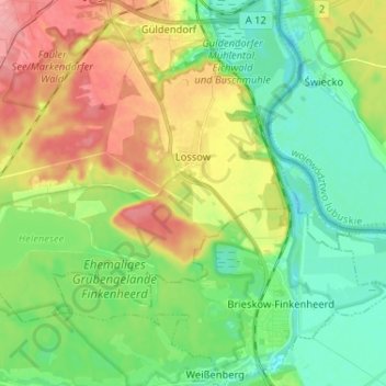
Name: Lossow topographic map, elevation, terrain.
Location: Lossow, Frankfurt (Oder), Brandenburg, Deutschland (52.25287 14.47216 52.30591 14.60136)
Average elevation: 48 m
Minimum elevation: 14 m
Maximum elevation: 103 m
Other topographic maps
Click on a map to view its topography, its elevation and its terrain.
Booßen
Deutschland > Brandenburg > Frankfurt (Oder)
Booßen, Frankfurt (Oder), Brandenburg, Deutschland
Average elevation: 72 m
Bullenberg
Deutschland > Brandenburg > Frankfurt (Oder)
Bullenberg, Frankfurt (Oder), Brandenburg, Deutschland
Average elevation: 64 m