
Manzanillo topographic map
Interactive map
Click on the map to display elevation.
About this map
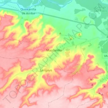
Name: Manzanillo topographic map, elevation, terrain.
Location: Manzanillo, Valladolid, Castile and León, Spain (41.56687 -4.27384 41.59946 -4.15130)
Average elevation: 825 m
Minimum elevation: 727 m
Maximum elevation: 908 m
Other topographic maps
Click on a map to view its topography, its elevation and its terrain.
Sad Hill
Spain > Castile and León > Santo Domingo de Silos
Sad Hill, Santo Domingo de Silos, Burgos, Castile and León, Spain
Average elevation: 1,219 m
Santo Domingo de Silos
Santo Domingo de Silos, Burgos, Castile and León, 09610, Spain
Average elevation: 1,144 m
Beberino
Spain > Castile and León > La Pola de Gordón
Beberino, La Pola de Gordón, León, Castile and León, 24600, Spain
Average elevation: 1,159 m
Guzmán
Spain > Castile and León > Pedrosa de Duero
Guzmán, Pedrosa de Duero, Burgos, Castile and León, 09314, Spain
Average elevation: 878 m
Mogarraz
Mogarraz, Salamanca, Castile and León, Spain
Average elevation: 804 m
Valdoré
Spain > Castile and León > Crémenes
Valdoré, Crémenes, León, Castile and León, 24810, Spain
Average elevation: 1,154 m
Grandal
Spain > Castile and León > Hontoria de la Cantera
Grandal, Hontoria de la Cantera, Burgos, Castile and León, Spain
Average elevation: 978 m
Villafranca del Bierzo
Spain > Castile and León > El Bierzo
Villafranca del Bierzo, El Bierzo, León, Castile and León, Spain
Average elevation: 910 m
Truchas / Trueitas
Spain > Castile and León > Truchas
Truchas / Trueitas, Truchas, León, Castile and León, 24740, Spain
Average elevation: 1,210 m
Veleta
Spain > Castile and León > Valle del Retortillo
Veleta, Valle del Retortillo, Palencia, Castile and León, 34307, Spain
Average elevation: 791 m
Aldeatejada
Aldeatejada, Salamanca, Castile and León, Spain
Average elevation: 838 m
Barbadillo de Herreros
Barbadillo de Herreros, Burgos, Castile and León, 09615, Spain
Average elevation: 1,448 m
Blanca
Spain > Castile and León > Riello
Blanca, Riello, León, Castile and León, 24127, Spain
Average elevation: 1,193 m
Portugal
Spain > Castile and León > San Justo de la Vega
Portugal, San Justo de la Vega, León, Castile and León, Spain
Average elevation: 929 m
La Hoya
La Hoya, Salamanca, Castile and León, Spain
Average elevation: 1,401 m
El Reventado
Spain > Castile and León > Fontiveros
El Reventado, Fontiveros, Ávila, Castile and León, 05309, Spain
Average elevation: 917 m
Ribera del Duero
Spain > Castile and León > Aranda de Duero
Ribera del Duero, Aranda de Duero, Burgos, Castile and León, Spain
Average elevation: 800 m
Belorado
Belorado, Burgos, Castile and León, 09250, Spain
Average elevation: 895 m
Zazuar
Zazuar, Burgos, Castile and León, 09490, Spain
Average elevation: 852 m
Palazuelos de Cuesta Urría
Spain > Castile and León > Trespaderne
Palazuelos de Cuesta Urría, Trespaderne, Burgos, Castile and León, 09213, Spain
Average elevation: 578 m
El Escobanal
Spain > Castile and León > Santa Cruz del Valle
El Escobanal, Santa Cruz del Valle, Ávila, Castile and León, 05410, Spain
Average elevation: 600 m
Ciudad Rodrigo
Ciudad Rodrigo, Salamanca, Castile and León, Spain
Average elevation: 709 m
Albuera
Spain > Castile and León > Valle de Manzanedo
Albuera, Valle de Manzanedo, Burgos, Castile and León, 09146, Spain
Average elevation: 834 m
Castillo Grande
Spain > Castile and León > La Puebla de Arganzón
Castillo Grande, La Puebla de Arganzón, Burgos, Castile and León, 01230, Spain
Average elevation: 612 m
La Mata de la Bérbula
Spain > Castile and León > Valdepiélago
La Mata de la Bérbula, Valdepiélago, León, Castile and León, 24846, Spain
Average elevation: 1,169 m
Villamediana
Villamediana, Palencia, Castile and León, 34239, Spain
Average elevation: 812 m
Alcubilla de Avellaneda
Alcubilla de Avellaneda, Soria, Castile and León, Spain
Average elevation: 951 m
Contreras
Contreras, Burgos, Castile and León, Spain
Average elevation: 1,089 m
Olmedo
Olmedo, Valladolid, Castile and León, 47410, Spain
Average elevation: 765 m
Peñalara
Spain > Castile and León > Mambrillas de Lara
Peñalara, Mambrillas de Lara, Burgos, Castile and León, 09642, Spain
Average elevation: 1,071 m
Pino del Río
Pino del Río, Palencia, Castile and León, 34110, Spain
Average elevation: 1,043 m
Jaramillo de la Fuente
Jaramillo de la Fuente, Burgos, Castile and León, Spain
Average elevation: 1,117 m
Saucelle
Saucelle, Salamanca, Castile and León, 37257, Spain
Average elevation: 487 m
Garray
Garray, Soria, Castile and León, 42162, Spain
Average elevation: 1,080 m
Ferreras de Arriba
Ferreras de Arriba, Zamora, Castile and León, 49335, Spain
Average elevation: 920 m
Las Nievas
Spain > Castile and León > Valle de Valdelucio
Las Nievas, Valle de Valdelucio, Burgos, Castile and León, Spain
Average elevation: 958 m
Poblado del Salto de Aldeadávila
Spain > Castile and León > Aldeadávila de la Ribera
Poblado del Salto de Aldeadávila, Aldeadávila de la Ribera, Salamanca, Castile and León, 37254, Spain
Average elevation: 535 m
La Fregeneda
La Fregeneda, Salamanca, Castile and León, Spain
Average elevation: 421 m
Vilvestre
Vilvestre, Salamanca, Castile and León, 37258, Spain
Average elevation: 532 m
Fresno de la Vega
Fresno de la Vega, León, Castile and León, 24223, Spain
Average elevation: 762 m
Hinojosa de Duero
Hinojosa de Duero, Salamanca, Castile and León, 37230, Spain
Average elevation: 523 m
Mieza
Mieza, Salamanca, Castile and León, 37254, Spain
Average elevation: 619 m
Carucedo
Spain > Castile and León > El Bierzo
Carucedo, El Bierzo, León, Castile and León, 24442, Spain
Average elevation: 637 m
La Bouza
La Bouza, Salamanca, Castile and León, 37488, Spain
Average elevation: 622 m