
Langa topographic map
Interactive map
Click on the map to display elevation.
About this map
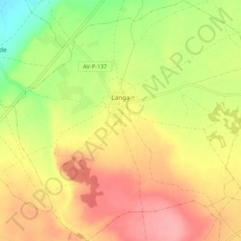
Name: Langa topographic map, elevation, terrain.
Location: Langa, Ávila, Castile and León, Spain (40.97527 -4.89068 41.02959 -4.81881)
Average elevation: 869 m
Minimum elevation: 814 m
Maximum elevation: 913 m
Other topographic maps
Click on a map to view its topography, its elevation and its terrain.
Burgos
At an elevation of 865 metres (2,838 ft), the city of Burgos lies in the transition zone between a Warm-summer Mediterranean climate (Köppen Csb) and an Oceanic climate (Köppen Cfb), with some continental influence resulting from its distance from the sea and higher altitude. Burgos' climate features chilly…
Average elevation: 907 m
Salamanca
With an altitude of over 800 meters, Salamanca has a warm-summer Mediterranean climate (Csb) according to the Köppen climate classification, with some cold semi-arid climate (BSk) climatic influences, resulting in large diurnal temperature variations, with hot summers and chilly winters, and nearly-semi-arid…
Average elevation: 812 m
Segovia
Segovia is one of nine provinces that make up the autonomous region of Castile and León. Burgos and Valladolid lie to the north, Ávila to the west, Madrid to the south, and Soria to the east. The altitude of the province varies from 750 metres (2,461 feet) in the extreme northwest to a maximum of 2,430 m…
Average elevation: 1,143 m
El Barco de Ávila
El Barco de Ávila is located at the southwest of the province of Avila, near the frontier of the provinces of Salamanca and Caceres, being the headboard of the region between the valley of the Tormes river and Aravalles river, better known as Alto Tormes. This municipality is located on an altitude of 1004…
Average elevation: 1,061 m
Ciudad Rodrigo
At an elevation of 658 metres (2,159 ft) Ciudad Rodrigo has an inland Mediterranean climate (Köppen: Csb) characterised by cool, damp winters and warm, dry summers with relatively cool nights during the summer.
Average elevation: 709 m
Poblado del Salto de Aldeadávila
Spain > Castile and León > Aldeadávila de la Ribera
Average elevation: 535 m
Aldeadávila de la Ribera
Aldeadávila de la Ribera has a predominantly gentle, hilly relief, typical of the Zamoran-Salamancan peneplain of the Northern Plateau, which contrasts with the deep river beds of the River Duero and its tributaries. Its average altitude ranges between 2395 ft and 2198 ft, with the highest point being the…
Average elevation: 619 m
Valladolid
Valladolid is located at roughly 735 metres above sea level, at the centre of the Meseta Norte, the plateau drained by the Duero river basin covering a major part of the Northwest of the Iberian Peninsula. The primitive urban core was built ex novo in the 11th century on a small elevation near the confluence…
Average elevation: 768 m
Ávila
Ávila's position results in a temperate Mediterranean climate (Csb, according to the Köppen climate classification), with warm summers and chilly winters with snowfalls, bordering on a cold semi-arid climate (BSk). The hottest month, July, has an average temperature of 20.6 °C (69 °F), and the coldest…
Average elevation: 1,157 m
Sierra de Guadarrama
Spain > Castile and León > Cuenca del Guadarrama
The range runs southwest–northeast, extending from the province of Ávila in the southwest, through the Community of Madrid, to the province of Segovia in the northeast. The range measures approximately 80 kilometres (50 mi) in length. Its highest peak is Peñalara, 2,428 metres (7,966 ft) in elevation.
Average elevation: 1,241 m