
Saddle Island topographic map
Interactive map
Click on the map to display elevation.
About this map
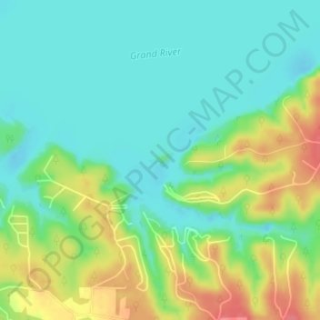
Name: Saddle Island topographic map, elevation, terrain.
Location: Saddle Island, Delaware, Oklahoma, USA (36.53516 -94.91978 36.53657 -94.91686)
Average elevation: 245 m
Minimum elevation: 222 m
Maximum elevation: 287 m
Other topographic maps
Click on a map to view its topography, its elevation and its terrain.
Bartlesville
USA > Oklahoma > Bartlesville
Bartlesville, Washington County, Oklahoma, USA
Average elevation: 236 m
Razorback Mountain
Razorback Mountain, Pushmataha County, Oklahoma, 74557, USA
Average elevation: 231 m