
Tipner topographic map
Interactive map
Click on the map to display elevation.
About this map
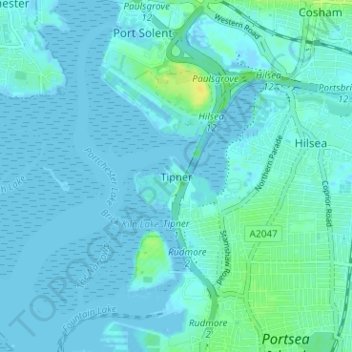
Name: Tipner topographic map, elevation, terrain.
Location: Tipner, Portsmouth, England, PO2 8RD, United Kingdom (50.80673 -1.11263 50.84673 -1.07263)
Average elevation: 3 m
Minimum elevation: -4 m
Maximum elevation: 18 m
England trails, hiking, mountain biking, running and outdoor activities
Other topographic maps
Click on a map to view its topography, its elevation and its terrain.